
Julie Fairey explains the proposed new Plan Change
There’s a lot of discussion and information flying around at the moment around the future of Auckland’s land rules, where more housing should and shouldn’t be, as Council faces a decision on a way forward later this month.
To help people across the Albert-Eden-Puketāpapa area understand this, City Vision is putting on a webinar on Monday 15 September at 7pm. Councillor Julie Fairey will explain how we got here, share maps and information, answer questions, and discuss next steps. We have a Facebook event for it and you can register online (and ask questions and give your suburb or area of interest).
We’re also providing this post chock full of info and links to further info, which we hope will aid understanding and get accurate info out there for everyone. It’s focused on the area we cover, but you’ll find much of the info applies across urban and suburban Auckland.
The decision being made by Auckland Council on Wednesday 24 September is whether to continue with Plan Change 78, which was notified in 2022 in response to the Medium Density Residential Standards (MDRS) legislation, or to replace it with the proposed new plan change.
To be clear, there are only two options available to Council: continue with PC78, or withdraw it and notify a new plan, currently called the “Draft Replacement Plan Change”. This will not set the final rules and maps for either plan, and is a choice over which one Council should progress.
Returning to the Unitary Plan as it stood in 2016 is not an option, and anyone who says it is has seriously misunderstood the laws passed by Labour in their last term and National in this one.
Useful links (these are embedded at various points below too):
Unitary Plan viewer (see the current maps online)
PC78 viewer (see the proposed maps online)
PC78 information (includes timelines and links to proposed rules)
Draft replacement plan change information (includes links to proposed rules and PDFs with draft maps)
Myths v Facts on Auckland’s draft planning rules (9th September 2025)
Info sheet on how Special Character has been assessed under PC78 (and the new draft)
What are zoning and overlays?
The rules and maps show both zoning and overlays, and how they interact. Zoning is the underlying rules that apply to the land. This is usually represented by solid colours on the maps. A consistent legend is used for these across the region, but not all areas have all types of zones. A map that only shows zoning looks like this:

Three Kings town centre’s current zoning, from the Unitary Plan online viewer
Overlays are then applied over the top, and generally overrule the zoning rules. For instance, if the zoning allows building to 50m (15 storeys) but there is an overlay volcanic viewshaft that says actually it can only go to 11m (3 storeys), then the 11m from the overlay applies. There are also controls and designations, which work in a similar way to overlays, but for the sake of simplicity here I’ll focus on overlays.

The same area of Three Kings, with the overlay for Special Character (dots) and Historic Heritage (purple crosshatches).
In some cases there will be multiple overlays (and controls and even designations) interacting to influence how the rules play out for a specific piece of land. A resource consent is only required if a development is proposed to conflict with the rules, and makes an argument for why the proposal should go ahead despite that. It can result in negotiation for changes to comply or lessen the conflict, permission to break the rule(s), and/or a need for agreement from neighbours. That process will include weighing up the different rules that apply and how to apply them when they are at odds.
What are the MDRS?
The Medium Density Residential Standards were set in 2021 by legislation supported by both Labour and National. The core requirement of MDRS was for zoning to enable a baseline of three dwellings, up to three stories, on any urban site, though this would still be subject to rules such as ‘height in relation to boundary’ and site coverage requirements, overlays such as viewshafts, and qualifying matters such as special character and infrastructure constraints. It spread a lot of housing intensification around all our suburbs, and would mean a lot more infill housing across the region, with fewer tall buildings around town centres and transport hubs. More info on MDRS is at this Ministry for the Environment fact sheet.
Why only these two choices?
PC78 was required to be developed to replace the Unitary Plan, by legislation passed under the previous Labour government, and supported by National. It did not include a proposal for the light rail corridor (aka The Big Blankness) which runs through the middle of Albert-Eden-Puketāpapa, as the exact route of light rail was not confirmed. PC78 was notified in 2022 and received public submissions, but was paused in 2023 at council’s request so that Auckland could ensure it responded to flooding risks after the January and February storms. Council’s website has a section about PC78 that explains the timeline as well as providing lots of info, and there is an online viewer for PC78 too.
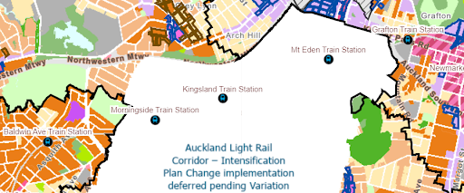
Screenshot from the PC78 online viewer, showing the northern end of the Big Blankness.
Since then it has become apparent PC78 would not be flexible enough, under the law, on flooding, the light rail project has been cancelled, and the City Rail Link is almost complete. Parts of PC78 like the City Centre have been able to be completed, but not the overall suburban planning rules. Council has been working with central government on a more suitable way forward for most of the last year. Housing Minister Chris Bishop’s amendments to legislation in August 2025 allows Auckland to opt out of the MDRS and address the shortcomings of PC78 only if it replaces PC78 with a new plan change that enables the same or greater potential housing capacity.
How are the plans different?
Auckland Council has put out two useful updates about this in recent weeks - Draft changes to boost flood protection and housing (21st August 2025) and Draft Planning Rules: Myths v Facts (9th September 2025).
Here’s our take on the key differences:
Flooding: PC78’s rules do not allow for any decrease in housing development (downzoning) on a site, even where flooding is an issue. The new plan change does allow for this, and some downzoning is proposed. There are also areas where density is proposed to increase by less than it would otherwise, and the new plan brings in a range of additional rules that significantly tighten consenting for flood prone sites (in section E36 of the new rules). These rules are not in PC78.
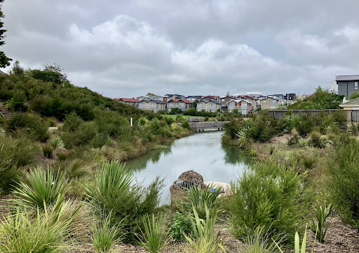
Freeland Reserve soon after the Easter 2025 floods. This blue-green network project saved nearby intensified housing from flooding.
Height limits within a short walk of train stations and some town centres: Under PC78 these are largely six-storey limits. The new legislation requires the new plan change must include higher limits for some areas (such as the headline-grabbing 10 or 15 storeys around railway stations). Greater Auckland wrote a useful post about what Government was proposing and why (written before the law was passed). While there has been a lot of discussion around increased height limits in the walkable catchments (the area within a short walk) of the five train stations in Albert-Eden-Puketāpapa, the new plan proposes increases for 12 other train stations, two bus stations outside the ward and the edge of four metro zones also outside the ward. NB: Viewshafts from our maunga (volcanic cones) remain the same in both plan change proposals and overrule the zoning height limits.
MDRS: PC78 has to enable MDRS and eliminate Single House Zoning in the urban area. The new plan does not have MDRS and is able to use Single House Zoning. The new proposal also adds a new “coastal character” qualifying matter, which is used to support lower zoning on coastal edges.
Light rail corridor: PC78 is silent on zoning and overlays in the area that previously was intended to have light rail running through it. This results in what we call The Big Blankness (as pictured above) over much of the ward, and makes comparisons between PC78 and the replacement proposal in those areas difficult. The new replacement plan has proposed zoning and overlays for that whole area, meaning it would not need a separate additional process and providing some certainty about what could happen in this large area of the isthmus. (More on this below.)

Medium density apartments along a frequent transport route (Great North Road, Waterview)
The flooding changes are particularly important for the suburbs of Waitematā and Albert-Eden-Puketāpapa, as they were hard hit by flooding in January 2023’s storms, and in some cases again in Easter 2025. While council is purchasing many Category 3 properties there, it is important to get the zoning right to ensure future use of this land does not put residents back in harm’s way, and reduces risk for neighbours.
What do the plans have in common?
Special character: the system used to assess special character is the same for PC78 and the new proposal. You can read more about that in the info sheet done for the PC78 process. Work done on special character during the PC78 process is reflected in the new proposal, adding and subtracting some special character areas by agreement. Although the assessment tools are the same, other rules which differ between PC78 and the new proposal have resulted in a few areas where special character differs between the two proposals. However, in most of the ward where the two maps can be compared, they show the same streets under the special character overlay.
Historic heritage: So far this appears to be identical between PC78 and the new proposal. Let us know if you spot anything that isn’t, as it may be an error.
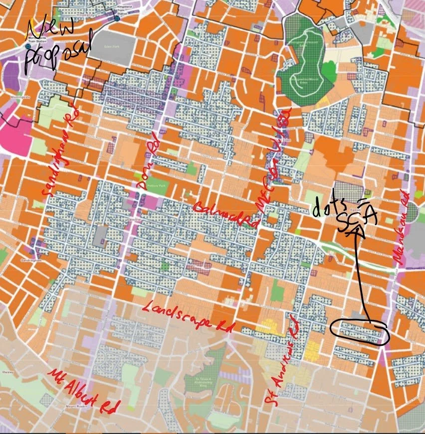
Current draft showing proposed special character (dots) and historic heritage (purple crosshatches) overlays in the draft replacement plan change maps (notations by Julie). This area is part of The Big Blankness under PC78.
Viewshafts: These are proposed to be the same for both plans. The Minister talked publicly about changing these but didn’t put it in the legislation, and it is not currently proposed to change them. They exist to protect views from and to landmarks, in particular our maunga.
Restrictions for infrastructure constraints (other than stormwater): These are assessed the same way, and in some cases we have more information with the new plan change than we had when PC78 was notified in 2022. You can find out more about Watercare’s network capacity planning work here and they are updating these maps on a regular basis now to give developers more certainty. For the isthmus, most areas have no capacity issues on wastewater or drinking water. For stormwater constraints see the part on flooding above.
What about the light rail corridor (The Big Blankness) in PC78?
When PC78 was notified, the exact route of the proposed light rail line through the central isthmus was uncertain, so an area around the potential route was set aside for future consideration when the light rail route was finalised, since light rail stops would require denser zoning in their walkable catchment, as with train stations.
Light rail was cancelled by the incoming government in 2023, so whether council proceeds with PC78 or with the replacement plan change, the area under The Big Blankness must be zoned in accordance with legislation.
Returning to PC78 would require a variation to fill in The Big Blankness. This variation would be largely similar to the proposed new plan change in terms of special character and walkable catchments.
The risk of returning to PC78 is that a variation would have to follow the MDRS and enable three dwellings of three storeys across most of this area, with no ability to downzone for flood risk. This would also remove underlying Single House Zoning in special character areas (as it is not allowed in urban areas under PC78).
Why is it happening so fast? And why hasn’t there been consultation?
The timeline for these changes have been set by the National-led coalition government. The Minister’s amendments require Council to notify the new plan (or to restart work on Plan Change 78) by 10 October 2025, which allows no time for the sort of early consultation done for Plan Change 78—it’s barely enough time for council planners to prepare the new maps. Council has been asking central government for months to pass the legislation needed to progress this work, to allow enough time for public engagement, so the short timeframe is frustrating.
If Council chooses to opt out of the MDRS by replacing Plan Change 78, the process after the new plan is notified will include public submissions to an Independent Hearing Panel. However, the timeframe for that is also set by the Minister, and may be short. It will be done through what is called the Streamlined Planning Process, as the Minister has already directed.
If PC78 is not withdrawn, we continue with that process. Submissions on PC78 were opened and closed in 2022, and in some cases hearings and decisions have been made, but not in regard to the broader issues of zoning our suburbs which remain outstanding. And of course we will need to develop a proposed variation for The Big Blankness, aka the light rail corridor. Public input to that variation may or may not be allowed by central government, who have indicated they don’t want councils to pursue any public plan changes (with a few exceptions) until after they have finished their own RMA reform process (possibly 2027).
Can’t Auckland just say no?
Sticking with the current Unitary Plan hasn’t been an option for some years. Laws passed by successive governments, red and blue, have required Auckland to provide significantly more housing capacity, leading first to PC78 and then to this new replacement plan change. Christchurch tried to say no and was overruled by the Minister recently, at a cost of $6m for a process that went nowhere.
This means that on 24th September, Auckland Council must choose either to continue with PC78 OR to withdraw PC78 and notify the new replacement plan change. There is no other option, by law. All indications from Government Ministers and central government officials are that they will not change the law they passed in August, even while some may be saying things publicly that suggest otherwise.
What happens after September 24th?
Central government, with some council input, will create or reinstate an Independent Hearings Panel of commissioners (not elected members) who will consider the proposals and any submissions. The commissioner panel will then make recommendations back to council for what should be “adopted” and then “made operative” (which means the new rules that will apply). Next the council will vote on whether to accept or reject those recommendations. In the current legal framework, if Council rejects any recommendations from the panel, then the Minister may choose to overrule Council.
If PC78 continues, then Council will need to work with the Minister on the process after it is unpaused. There may be opportunities for more public input before the Independent Hearings Panel makes its PC78 recommendations back to Council. But as official submissions have already closed, it is unclear what this would look like, including for the unzoned light rail corridor and any variation that could address flood-prone areas.
If the new replacement plan change continues, it will be officially notified and opened for public submissions. The timeframes for this, and the parameters of any hearings, will be up to the Minister. Council has made it clear the expectation that this should not happen over the Christmas break.
City Vision is keen to help folks to make submissions to whichever process comes next and make it as easy as we can, and will be looking at how to do that once we know the path forward.
Learn more about all of this (with more maps!) on Monday 15th September when Julie does an online information session on the processes, proposals and possible next steps. Register here, and the Facebook event is here.