
Your Almost Last Minute Helping Hand for PC120 Submissions
Everyone does stuff at the last minute sometimes. It’s so common that management-speak even has a name for it: Just In Time Delivery. And often the more complex something is, the later we leave it. PC120 is definitely complex, and the submission deadline is 5pm 19th December.
This blog post is written with Albert-Eden-Puketāpapa in mind, and based on dozens of one-on-one conversations I’ve had with constituents by email, in person and on social media, plus what I’ve observed at council-run info sessions and community meetings. The aim is to cover the key information that I find people want or need to understand to produce an effective submission. Hopefully it is useful for a wider audience too.
How to use this blog post:
For quick tips on making a submission, jump to the Quick Guide at the end of the post.
For more in-depth information, this blog post is broken up into parts that hopefully can be easily scrolled through to find what you want. You may need the whole thing, or you may just need a bit of info on actually submitting, or a specific qualifying matter (we’ll get to what that is). We’ve put headings in in bold and numbered them to help you find things as you scroll.
1. The Basics
1.1 What is PC120?
1.2 Why is PC120 happening?
1.3 Why two million extra homes?
2. The PC120 Proposal
2.1 Key principles
2.2 Patterns of development
2.3 More housing around train stations
2.4 Qualifying Matters
2.4.1 What are qualifying matters?
2.4.2 Flooding
2.4.3 Special Character Areas
2.4.4 Volcanic viewshafts
2.4.5 Combined Wastewater & Stormwater Infrastructure issues
3. Making a submission
4. What happens next
5. Quick Submission Guide
We’ve also included links to more information, in particular the Council’s info sheets on specific topics.
1. The Basics
1.1 What is PC120?
Plan Change 120 (PC120) is a proposal from council to change the rules of how you can use land, and where those rules apply, across much of urban Auckland. It has resulted from years of discussion and debate about how to address housing issues in Tāmaki Makaurau, and more recently specific legislation passed by central government in August. While the plan change has been put up by council it has been required by central government, and is based on parameters set by central government.
Council acknowledges that PC120 is not perfect, and that it needs improvement. It is based on principles that encourage more housing the closer you are to Auckland’s city centre, and around town centres and frequent public transport routes. You will see this pattern repeated across the region, with higher density housing proposed around train stations, shopping centres, and along major arterials with multiple bus routes like Dominion Road.
In some places there are reasons not to follow these principles, and those reasons are called Qualifying Matters. Where council thinks a qualifying matter exists, it has taken a different approach to what the principles would call for, usually proposing a lower level of housing intensity or putting an overlay on properties which apply rules on top of the zoning.
The next round of decision-makers on the plan change are nine independent commissioners who will consider submissions, undertake hearings and produce a set of recommendations (a full set of maps and a rule book) for council to vote on sometime in early 2027. Your submissions are going to those commissioners, not to councillors. Council will provide the admin support for the commissioners, but they are independent from both council and central government.
For more on the background of how Plan Change 120 came about, the shortages of housing Auckland faces, and some of the history including how it compares with Plan Change 78 which was previously worked on, check out this blog post I wrote in August.
1.2 Why is PC120 happening?
Very very briefly:
Auckland has had some level of housing crisis as long as I can remember (I’m as old as the original Star Wars).
Many attempts to come up with Plans (ie planning plans, not just any plans) to address this have fallen short. The most recent of these was the Auckland Unitary Plan, adopted by Auckland Council in 2016.
Central government (Labour-led and National-led) has got pretty frustrated with the inability of local government in Auckland to sort this and has in the last few years passed laws and set national policies to require Auckland Council to do better.
We were working on a way forward to do what central government required (and Auckland needed) called Plan Change 78 when the Auckland Anniversary floods hit in January 2023. A pause on that work was requested by council (and granted) because Plan Change 78 didn’t recognise flood risks and would have proposed more housing in places of high risk.
Lots of negotiation with central government later, Plan Change 120 was quite quickly put together for public consultation, based on previous work, and here we are now.
1.3 Why two million extra homes?
Plan Change 120 needs to increase the number of homes that could theoretically be built in Tāmaki Makaurau by two million, excluding rural areas and the city centre. This is because the previously developed Plan Change 78 created theoretical capacity for this amount, and central government requires Plan Change 120 to rmatch that.
It’s important to understand that the two million is a theoretical number; it’s the extra homes that could be provided if every single property in Auckland was developed to its maximum capacity with no limitations (which. But in reality there are limitations: overlays for issues like flooding and viewshafts, and properties that are not big enough to build to the limit within the zone’s rules, or it’s not commercially viable, or the owner just doesn’t want to. The two million figure is plan-enabled capacity, not feasible development (ie what is commercially viable to build, which Christchurch have had to work to). This plan change does not mean two million more dwellings will be built; it’s just the way that the legislation requires us to measure it against PC78. In reality, many fewer dwellings will actually be feasible to build over the next few decades.
Part of the difficulty is that one million of those two million extra homes in Plan Change 78 were created through the Medium Density Residential Standards. Those disappear under Plan Change 120 (and most people think that’s a good thing), so there’s a need to find places to add in those extra dwellings. This is why Plan Change 120 proposes higher density in some areas than Plan Change 78 did. Put simply, PC78 required increases in density all over the urban and suburban parts of Auckland, whereas Plan Change 120 removes some of that density from the suburbs and puts more of it closer to train stations and town centres. Auckland Council’s chief economist has done some analysis showing how housing demand is higher in those areas too. I go into a lot more detail about PC78 versus PC120 in my August blog post. This image shows the difference in development pattern between the two plan changes:

Image: Knowledge Auckland
Council voted in September 2025 to withdraw PC78 and move forward with PC120, but PC78 is still relevant as it was an important step along the way to the proposal now out for submissions. For instance, Special Character Areas for most of the Albert-Eden-Puketāpapa ward are the same in PC78 and PC120, as the assessment methods developed for PC78 were also used for PC120.
It’s important to note that the city centre is not included in Plan Change 120, as it is one of the few parts of Plan Change 78 that were completed before it was withdrawn. It has already had some increased housing density applied (which in the city centre generally means apartment buildings can be taller to have more homes within them).
2. The PC120 Proposal
2.1 Key principles
The key principles of Plan Change 120 are:
more housing closer to the city centre, by frequent public transport stops and routes, around town centres, and where there is other infrastructure capacity.
where there is a good reason not to put more housing in those locations, there needs to be an approved qualifying matter to reduce the housing density, either through lower density zoning or through an overlay that applies additional rules.
2.2 Patterns of development
You can see this pattern pretty clearly if you zoom out to look across the whole isthmus—how the dark orange (Terraced Housing and Apartment Buildings, aka THAB)
follows the Western and Southern train lines, and the roads with frequent bus routes such as Dominion Road, Sandringham Road, New North Road.
Clusters around town centres (which themselves are usually coloured pink, sometimes with some purple)
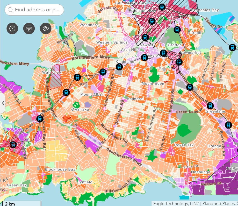
Proposed zoming in the central isthmus shown in the PC120 map viewer
You can also see how the dark orange (THAB) gets less frequent, shading to light orange (Mixed Housing Urban), yellow (Mixed Housing Suburban) and then cream (Single House Zone), the further you go from a town centre, bus or train line, which you can see well in this map of Lynfield. (I’ve added a blue line to show where the 25L bus runs)
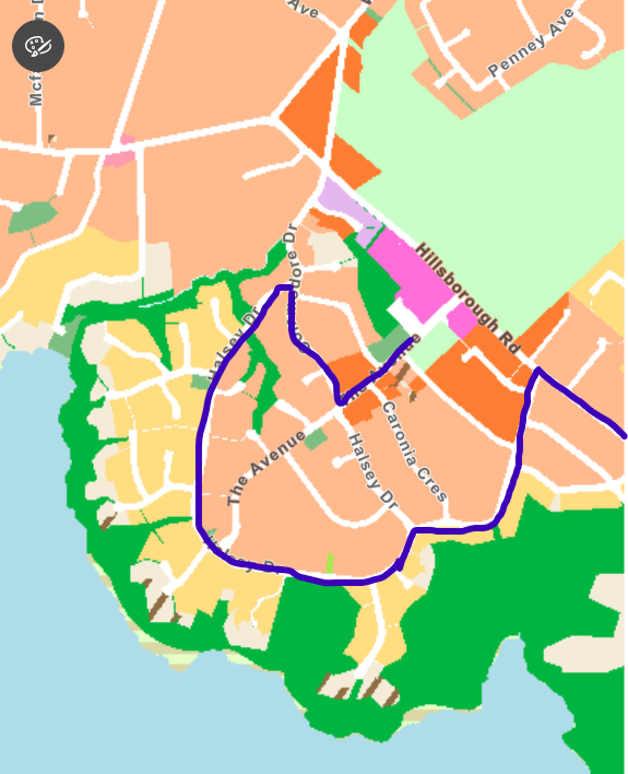
Lynfield, shown with the blue line representing the 25L bus route
2.3 More housing around train stations
Central government has also required council specifically to increase residential housing heights around five named train stations to a minimum of 10 storeys (Mt Albert and Baldwin Ave stations) and 15 storeys (Morningside, Kingsland and Maungawhau/Mt Eden stations). Council has put these minimums in the Plan Change 120 proposal. It has also proposed to treat some other train stations and major town centres similarly to provide consistency and help reach the two million extra capacity required.
The height requirements from central government have had a knock-on effect on how much Special Character Area is proposed to be retained within a short walk of those specific train stations. For Mt Albert and Baldwin Ave, the Special Character Areas are roughly the same as those proposed in the previous Plan Change 78, but for Kingsland and Maungawhau stations, quite a lot less has been able to be included. Council planners are testing the waters with what is proposed: keeping some Special Character Areas around these five train stations could be taken as frustrating central government’s instructions. It will be up to the commissioners how they treat this. (More on Special Character Areas below.)
2.4 Qualifying matters
2.4.1 What are qualifying matters?
Where there is a good reason not to put more housing in those locations, there needs to be an approved qualifying matter to reduce the housing density either through lower density zoning or through an overlay that applies additional rules for development. This info sheet explains qualifying matters.
The main qualifying matters which I’ve been asked about are:
Natural Hazards (which includes flooding)—info sheet
Volcanic viewshafts—no info sheet
Special Character Areas—info sheet
Combined Wastewater and Stormwater Infrastructure—no specific info sheet, this is covered in the main qualifying matters info sheet.
There are others too, such as Coastal Inundation, Notable Trees, and more, but I’m focusing here on the ones that I’ve been asked about consistently, on the basis those are the ones folks probably need more info on for their submissions. You can watch a video that shows how to use the map viewer so you can see the qualifying matters through turning overlays on and off.
For each of the four qualifying matters looked at in more detail below, I’ve included at the end some key points to consider if your submission covers that.
2.4.2 Flooding (part of Natural Hazards)
The E36 rules apply to other hazards too (such as landslides). It represents a significant change in language around hazard risks from previously. You can read it in more detail here, but this screenshot gives a sense of the shift in focus: much more prescriptive language focused on avoiding and reducing risk rather than managing it:
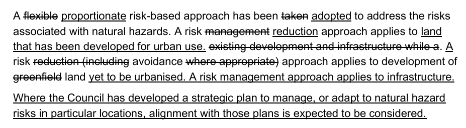
The bits crossed out are proposed to be removed, and the bits underlined are new additions.
The E36 rules applied applied immediately on notification of PC120, which is unusual; most things in the proposal won’t apply until it is all voted through sometime in 2027. But where there is a strong case to take a precautionary approach to reduce risk, such as with flooding, the rules took effect from November 3rd 2025. They may still be changed in the final plan, but for now the proposed rules apply.
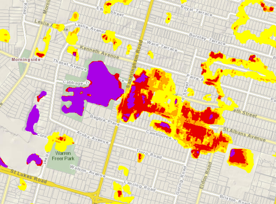
The main thing to understand about how flooding is treated in PC120 is that these E36 rules apply to flood risk in the blue blobs in the Natural Hazards overlay, like these:
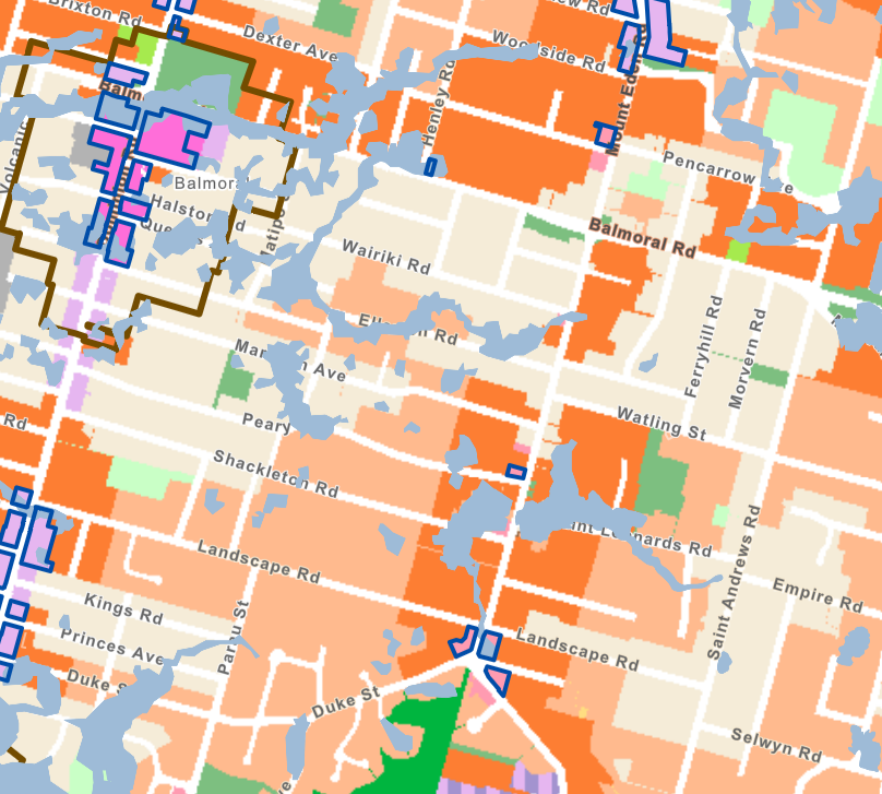
The blue blobs show areas of flood risk in Balmoral and Mt Eden
Flooding risk was one of the main reasons PC120 needed to happen—previous plans (including PC78) didn’t take flooding risk seriously enough. There is an argument that PC120 doesn’t go far enough too, and I imagine there will be submissions making that point, as well as others saying the proposed restrictions on properties with flood risk go too far. Another tricky one for the commissioners to balance up.
How the E36 rules apply to specific properties depends on the level of risk for that site and the type of development proposed. It may be that the risk isn’t too high, or that the type of development planned mitigates it, or both, in which case a resource consent would probably allow it.
The Natural Hazards info sheet (updated on 11th December) goes into a lot of detail about how these site-by-site assessments may work, including this flow chart for flood risk:
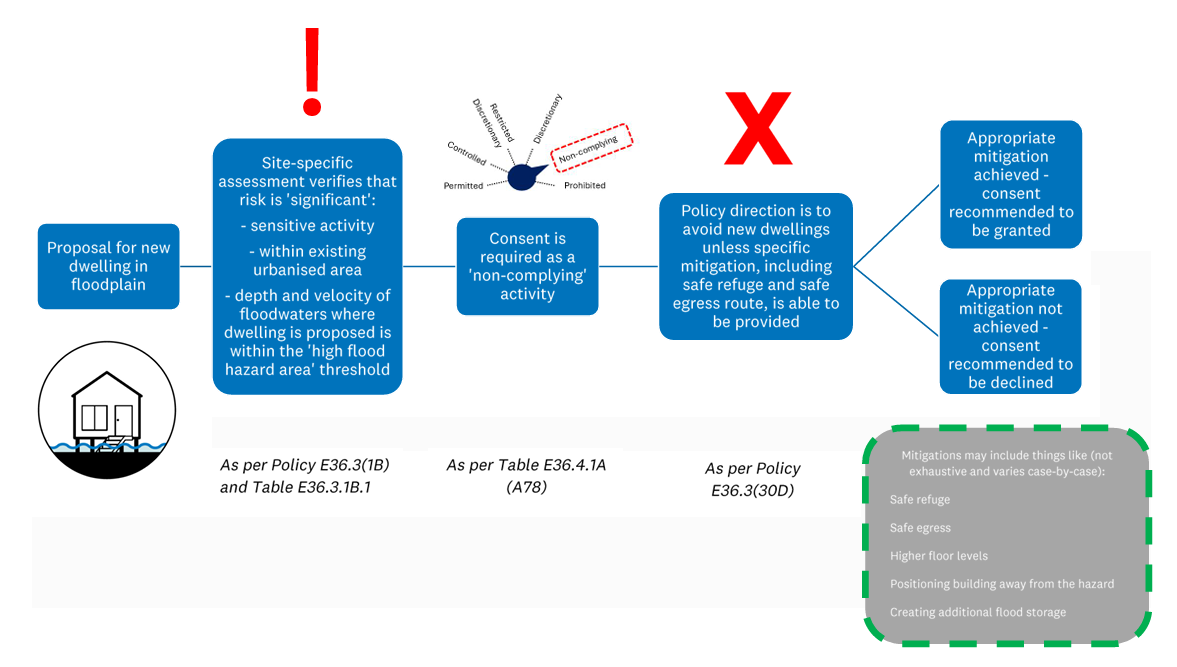
This chart from the Natural Hazards info sheet shows a potential consenting decision process for proposed development in a floodplain area
In a few cases, planners have proposed that it would be impossible to develop a site in a more intense way safely, so it has been given the lowest level of zoning possible (Single House Zone). You may or may not think that more properties should be treated that way. I’ve asked for some information on how much extra development opportunity (ie extra homes) would be lost if more of the blue blob areas were made Single House Zone. Because of the central government requirements, any housing capacity reduced in one place needs to be made up in another, so it would likely be necessary to increase density in other areas to make up for this.
Some additional information that can help you with your submission on this topic is held in GeoMaps (a different online mapping tool from the PC120 map viewer). There’s an info sheet on how to access that here. Basically it breaks down the blue blobs further to show the levels of risk within the blue blobs. Purple is the highest risk and yellow the lowest.

Flood risk in the same area of Sandringham/Mt Eden is shown in the PC120 viewer (left) and Geomaps (right).
For the purple parts, E36 rules would be applied very strictly to the details of any proposal, whereas for the yellow areas it would likely be more focused on ‘can people leave safely in a flood?’ Orange and red are in between. Where a property has been downzoned to Single House Zone it will probably be in the purple, but not all purples are downzoned.
(As an aside, PC120 isn’t the only thing council is doing about the flood risks to Aucklanders. There’s a whole lot more work around more resilient stormwater infrastructure, such as blue-green network projects. Some are already underway in Mangere, out west and on the North Shore, and one is coming for Mt Roskill. There’s also the Category 3 buy-out scheme, which PC120 doesn’t take into account, because PC120 doesn’t care who owns the land, just what is allowed to happen on it.)
Key points to look at if your submission covers flooding:
Within the blue blobs on PC120, what colours have been given to the area in GeoMaps?
How do those colours match up with the underlying zoning proposed, e.g. has all the purple been proposed as Single House Zone?
What is your personal experience of how stormwater has impacted the area, and not just in the most extreme events of January/February 2023? Does the modelling reflect what you have observed in terms of the depth and speed of the floodwaters?
Are there examples of dwellings in your area (or elsewhere) that have dealt well with flooding, or been more at risk, and what features of these dwellings increased or decreased the risk?
Further links:
GeoMaps info sheet
Auckland Council’s Flood Viewer: this shows overland flow paths, as well as flood areas and coastal inundation
2.4.3 Special Character Areas
Special Character Areas (SCAs) are about streetscape, ie the experience someone has as they walk along the street. It is not about the heritage value of particular buildings, and is different from Historic Heritage. The assessment for Historic Heritage is quite different from Special Character; only one street in my ward meets the threshold for that level of protection (Burnley Terrace in Mt Eden).
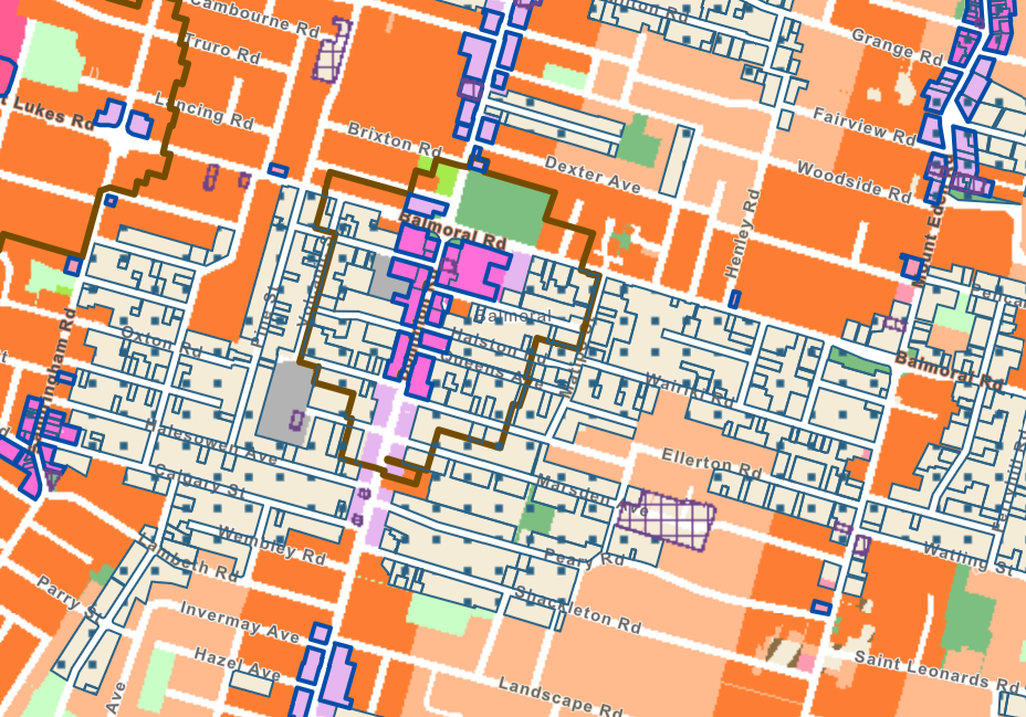
PC120 map with SCA overlay shown by blue dots, in Balmoral.
Special Character Areas have all been assessed individually by council staff and scored. You can find the assessments for each area in the section of the PC120 info titled Special Character Documents. There’s quite a lot of detail, which can be really useful when your submission is covering a specific Special Character Area.
The assessment methods are outlined in the Guidance information. Basically each area gets a percentage score and the higher the score, the more likely it is to be proposed to stay Special Character Area, which then in turn usually means Single House Zone is proposed as the underlying zoning. Points are gained for having clearly visible house fronts that look like a particular age and style of housing, and lost for alterations that undermine that, or things like high fences which make it less visible. The fewer houses in a Special Character Area that have been modified or replaced by more modern builds, the higher the percentage score.
The scores then have different impact according to where the Special Character Area is located, e.g. if it is near public transport or a town centre, or in the walkable catchment of one of the five train stations named in the legislation:
Within a short walk from a frequent public transport route or town centre: the Special Character Area must score 75% or higher to be maintained
Outside a short walk: the Special Character Area must score 66% or higher to be maintained.
Within the walkable catchments of Maungawhau/Mt Eden, Kingsland, Morningside, Baldwin Ave and Mt Albert train stations: planners have proposed only small amounts of Special Character Areas so as not to frustrate central government’s direction to allow 10 or 15 storeys. The areas proposed all score 75+%, but not all the areas scoring 75+% in the walkable catchment are included: planners have chosen areas that are physically contiguous (eg The Avenues, the Brentwood estate). It remains to be seen how the commissioners will treat these parts of the proposal.
Key points to look at if your submission covers Special Character Areas:
Is the property/street in a walkable catchment, or could it be argued to be in or out of one, which would affect the percentage score threshold?
What percentage score did the area receive in the council survey?
What individual score did a property receive in the council survey?
Have changes happened since the council survey which would impact the scores if it was done again?
Further links:
Info sheet on Special Character Areas
Guidance document on how Special Character Areas have been assessed
Info sheet on Intensification in Walkable Catchments which has a bearing on the SCA scores
To find the specific Special Character Area you are looking for information on, the surveys council has done are all available online. The links are about half way down the main PC120 page and look like this:
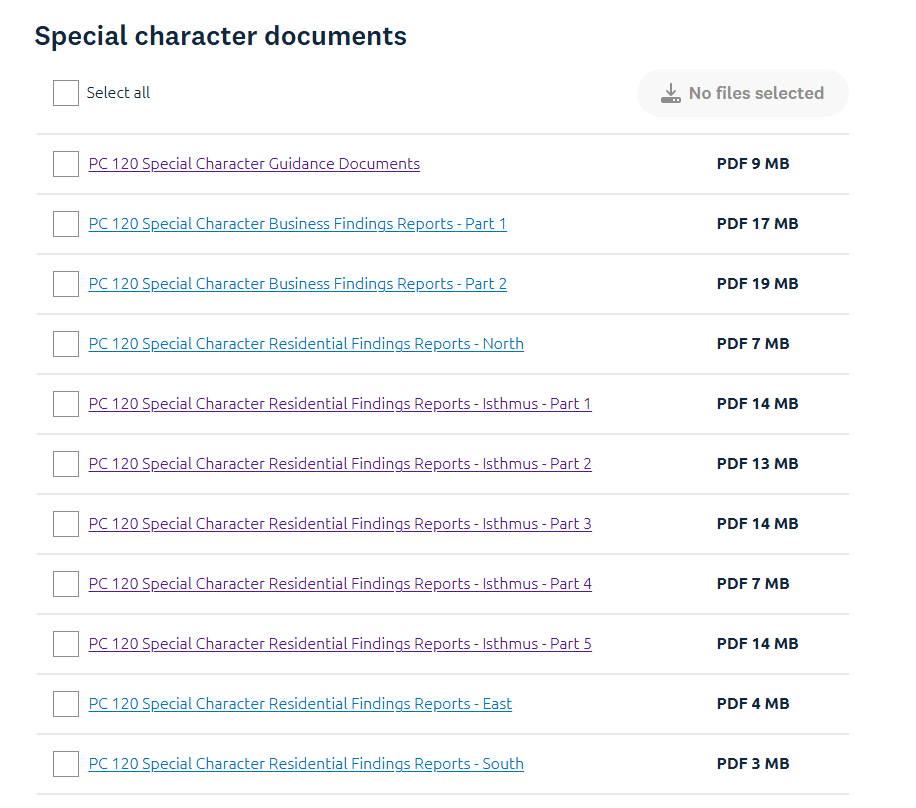
Hot tip: Use the search function for the document when you open it to look for the street name you are after. If that doesn’t work, try the suburb.
2.4.4 Volcanic Viewshafts
A viewshaft is a protected view from a specific point to a specific point. Many of our maunga (volcanic cones) have multiple viewshafts, so that from particular public places the views of parts of the volcanic hills are protected. Viewshafts act as additional height restrictions over the top of the underlying zoning. They are represented on the maps with green-brown upside down triangles within lines that can stretch out quite a long way.
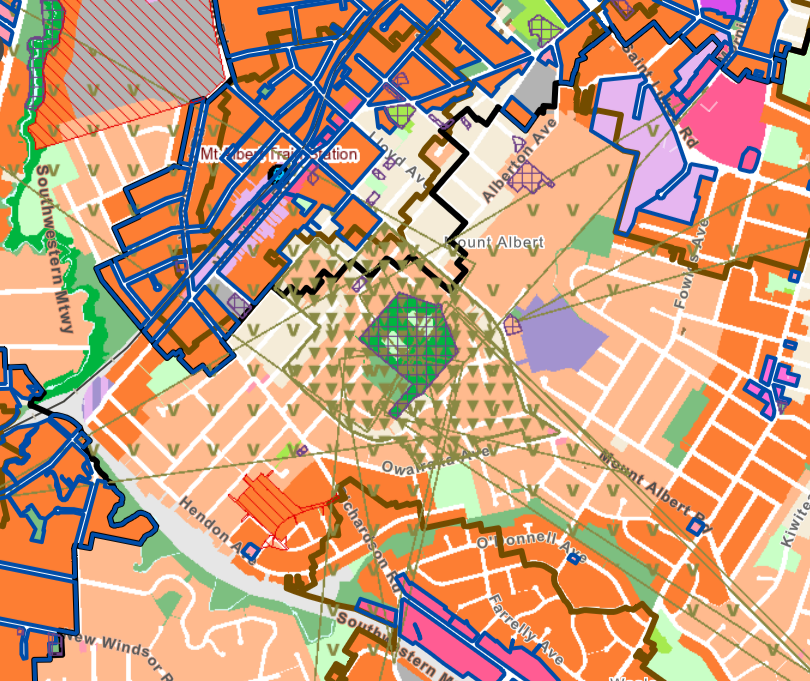
PC120 map showing viewshafts over Ōwairaka Mount Albert (green triangles)
The viewshafts operate in three dimensions, and the maps represent them in two. So it’s hard to know what the height limits are at different points along their lengths. There is no proposal in PC120 to change any of the viewshafts, though the commissioners may well look at changes in response to submissions.
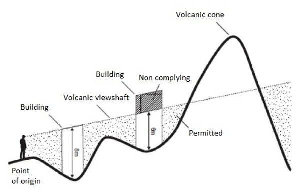
A diagram showing how a viewshaft’s height can vary at different points (image: Greater Auckland)
The most famous viewshaft is known as the Toll Booth viewshaft (E10): the view of Maungawhau Mt Eden from where people used to stop to pay the toll to cross the Harbour Bridge from the North Shore. E10 goes right across the harbour and the city centre, restricting development underneath it so that no building can puncture the viewshaft by building into it.
In some cases the zoning has been adjusted already to reflect the impact of viewshafts, as you can see in this map around Maungawhau itself:

PC120 map showing Maungawhau Mount Eden with viewshafts (green triangles)
The mid-orange close to the maunga is close to frequent public transport and the Mount Eden town centre, so should really be dark orange, but because of the many viewshafts it is already limited to three storeys. But in other areas, the viewshafts are harder to zone comprehensively for and will just apply over the top of the underlying zoning.
Key points to look at if your submission covers viewshafts:
Do you support or oppose viewshafts in general?
Do you support or oppose any particular viewshafts?
2.4.5 Combined Wastewater & Stormwater
Generally on the isthmus there are no issues with future wastewater capacity: we can add more toilet connections without too much worry that the big pipes can deal with it. Watercare has done a lot of modelling on this, and will continue to do so. This shows part of the regional map they have produced:
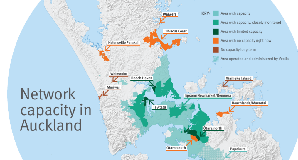
Watercare’s map of wastewater network capacity in Auckland
However, in some areas there is a known issue around having old systems that combine wastewater and stormwater. This means there isn’t as much capacity for further development on those properties until those systems are improved. This is represented in the overlays as blue diagonals, as here around the Point Chevalier town centre:
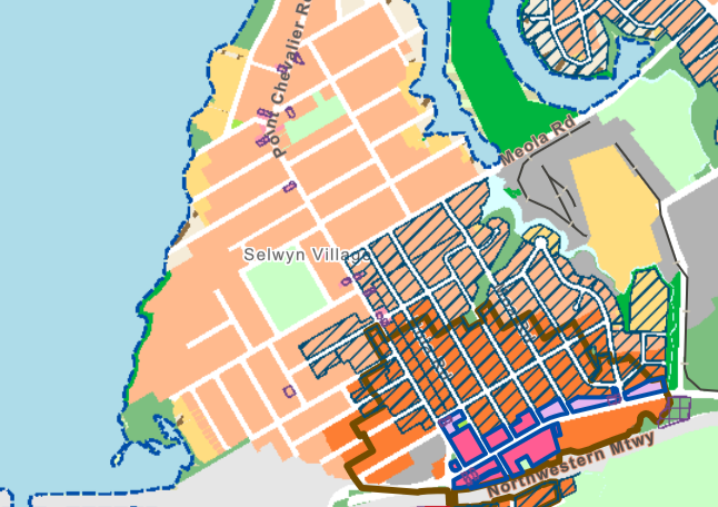
PC120 map showing the combined network overlay (blue diagonals) around Point Chevalier
Any developments proposed will need to take that limitation into account and manage it. Depending on the site and the development that is planned for it, this may mean a limit on how many new wastewater connections (eg toilets) can be added, for example.
Key points:
Does this overlay cover the area you are submitting about?
How do you think this should influence development for those sites?
Any personal experience of issues with combined stormwater and wastewater in an area covered by the overlay.
Further links:
Watercare’s work on network capacity
3. Making a submission
The only way to have your say is by making a submission, as independent commissioners are the decision-makers for the next step. Elected members like your local councillors, the mayor and local board members (and even Members of Parliament) do not have influence over the recommendations the commissioners will make. The nine independent commissioners are appointed by council or the Minister, but once appointed they are not directed by either local or central government and must weigh the submissions alongside resource management law and evidence from experts.
You can use the online submission form, or email your submission to [email protected].
Top tips:
The deadline is 5pm Friday 19th December. Between 4.45pm and 5pm on Friday, it’s best to email your submission instead of using the form.
Check out the video on how to make a submission.
If you don’t know the precise rule(s) your feedback refers to, that is OK—those parts of the online form are optional.
Make sure to include specific streets and addresses to support commissioners looking at the correct properties and areas.
Your name and address from your submission has to be made public, by law. Unfortunately you cannot request confidentiality. If this is an issue, you may want to see if there is a group you can work with to make your points.
Some issues, while important, are not matters that can be taken into account by the commissioners. Those most commonly raised with me are: impact on property values (and rates), school capacity and car parking. School capacity is the responsibility of central government, not council. Parking minimums (requiring developments to include a minimum number of on-site car parks based on a formula) were removed by law some years ago. You can put these kinds of issues in if you wish. of course, but be aware they may not be effective points to raise.
4. What happens next?
After submissions close, all of the submissions will be collated and published online. Behind the scenes, council staff will be working on pulling out themes and putting together all the points raised that apply to each street and rule and type of zoning, for the commissioners to break the input down into topics to work through systematically.
The commissioners will call for a further round of submissions. This is when those who have made submissions will be able to respond to other submitters’ points. Once those have closed, those further submissions will be published too, and analysed for the commissioners, and then there will be hearings, themed around specific topics.
Once the commissioners have completed all the hearings, they will start the mammoth task of formulating a final plan (maps and the rules that accompany it). Then they will produce a set of recommendations that go back to Auckland Council for your elected members to vote on. Central government has given a deadline for the whole process to be completed within 20 months, so this is likely to be all done in the first half of 2027.
PS: How this will work in with the recently announced resource management law reform from central government is currently unclear. There is a risk that the final plan will be at odds with what is allowed under the new planning regime being established… Don’t let that stop you submitting and taking part in the process we have now!
5. Quick Submission Guide
To make a submission, you can use the online submission form, or email your submission to [email protected].
You can upload up to three supporting documents, or type directly into the submission form. (If you have more than three documents, use email instead.)
Contact details: you must include these, and by law they will be made public. If this is an issue, you can look for a local group to join in with on a group submission.
‘My submission relates to:’ (e.g. rules, addresses, maps): this is optional, but useful if you are making points about a specific detail or location.
Some possible points to cover:
Your overall views on PC120: whether you think the draft plan should be approved, and why or why not.
Whether you support the general principles of the proposal (more housing closer to the city centre, by frequent public transport stops and routes, around town centres, and where there is other infrastructure capacity, with qualifying matters where there is good reason not to add more housing, such as flood risk).
Qualifying matters:
Flooding:
Your personal experience of flooding: does the proposal capture the flood risk in the area(s) you’re looking at?
Are there examples of dwellings in your area (or elsewhere) that have dealt well with flooding, or been more at risk?
What features have increased or decreased the risk?
Special Character:
What percentage score did the street or area you’re looking at receive in the council survey?
Is the property/street/area you’re looking at in the walkable catchment of a train station/frequent public transport/town centre? Could it be argued to be in or out of the walkable catchment (which would affect the score required for retaining it in the proposed plan)?
What individual score did a property receive in the council survey?
Have changes happened since the council survey which would impact the scores if it was done again?
Volcanic viewshafts:
Do you support or oppose viewshafts in general?
Do you support or oppose any particular viewshafts?
Combined wastewater/stormwater network:
Does the combined network overlay cover the area you are submitting about? Should it?
How do you think this should influence development for those sites?
Any personal experience of issues with combined stormwater and wastewater in an area covered by the overlay.